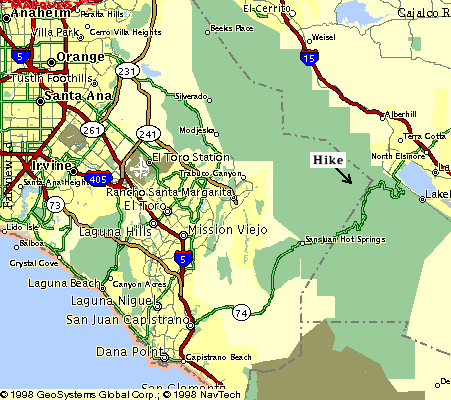
From the intersection of Interstate 5 and Highway 74 (Ortega Highway) drive east 19 miles until you see the Ortega Oaks Store, also known as the candy store. There are no other buildings on the right for many miles before the store, so you can't miss it. From there continue a little over two miles more, still on Ortega Highway, to where a paved road joins on the left. I don't remember what the sign there says for sure, but it is "Enchanted Oaks" or something similar. Exit there. The road is paved all the way to the trailhead and is suitable for any kind of passenger car, although it is narrow in places. Don't take any dirt road exits, and basically continue straight ahead at intersections. The distance is about 2½ miles. The road is shown on the topographic map, but the map is old and it may not be completely accurate. There is a teenage detention center about halfway there on the left.
There is a tiny parking lot on the left at the trailhead, but there are no signs, so plan on missing it the first time. The entrance to the Blue Jay Campground is a couple of hundred feet beyond the parking area, and it is marked by a prominent sign on the left. Turn around if you reach the sign. The San Juan Trail begins on the left side of the parking area. There are some minor paths to the Blue Jay Campground, so pick out and stay on the most heavily used trail.
If the parking area is full (it only holds five cars) then
go back the way you came for a few hundred feet where there is
a second parking area. If it is full too then go on past the
entrance to the Blue Jay Campground and park on the shoulder of the
road. A National Forest Adventure Pass is required for parking anywhere
in this region. They are available at the candy store, REI,
Sports Chalet, and other places.